5.0 ISLAND RESIDENTS (1793-1867)
Soon after purchasing McNabs Island in 1782, Peter McNab I acquired a number of tenants who helped clear the island and assisted in watching over the Governor's sheep. Thomas Fraser was the first such tenant. Fraser had fought in the Battle of Culloden in 1746 where "Bonnie" Prince Charlie had seen his dream of a Stuart Restoration destroyed. He came out to Halifax when the discharge of soldiers had occurred following the war.
The assessment role of 1793 shows a sizable population on McNabs Island. In that year, ratepayers and their livestock (or occupation) were as follows:
Thomas Fraser - 3 cows
William Cooper - labourer
James McNab - 1 horse and 4 cows
John Watts - labourer
James Peters - l cow
Beriah Rice - labourer
Peter McNab, Jr. - 2 horses, 12 cows, 200 sheep
George Ray - labourer
John McNab - labourer
Henry Kuhn, Sr. - 1 horse, 4 cows
--- Hawthorne, Jr. - 4 cows
David McGarth - labourer
Henry Kuhn, Jr. - labourer
With the addition of wives, children and other dependents, the island's population totalled about 50 at this time.
On June 12, 1796, James Hawthorne, one of the island residents, petitioned the government for assistance after his house burned. In his petition, Hawthorne noted that he had lived on the island for four years and was of "extreme old age." Hewitt notes that Hawthorne first lived on Green Hill, at the southern end of the island, but then moved to what was to be called Hawthornes Point and is now known as Hugonin Point.
John Little, a Scotsman, was known as Squire Little and lived by Fort Ives in the place at one time inhabited by Peter II. Hewitt records that Little was, before the incorporation of Halifax in 1841, its chief magistrate.
Another survey of ratepayers, conducted between 1798 and 1800, indicates an even larger population on McNabs Island. The twenty-one ratepayers listed in this survey were as follows:
Thomas Fraser James Peters
James Anderson ----- Williams
John Wright Donald McIntyre
John Modest Beriah Rice
John Cook George Ray
William Cooper Andrew Johnson
Roger Swinney Peter McNab, Jr.
James McNab John McNab
John Watts Henry Kuhn, Sr.
Henry Kuhn, Jr. John Quinland
John Munday ----- Williams
An 1808 map entitled "Plan of the Peninsula and Harbour of Halifax," completed by John G. Toler of the Royal Engineers, illustrates the location of several of the island's inhabitants (Figure 15). McNab's house and barn are shown near the shores of McNab Cove. Culliton (also incorrectly spelled as "Cullerdon," "Cullerton" and "Culleton,"), Peter II's father-in-law, lived several hundred yards south of the McNab residence. The MacLean farm is situated on the eastern side of the island. The Fraser farm, presumably that of Thomas Fraser, is located near Ives Cove. Several additional buildings clustered near Ives Cove, and others located immediately east of the Fraser farm, no doubt were occupied by some of the previously mentioned ratepayers.
A 1991 archaeological survey of the north end of McNabs Island uncovered several sites of archaeological value relating to the island's early settlers. Artifacts recovered from test pits at two foundations near Indian Point date from between 1800 and 1840 and are believed to mark the location of the Trainer and Kuhn dwellings.
Interestingly, the 1808 map also shows "an old fort" located in the vicinity of present-day Fort Ives. This is the same fort that was partially built in 1762 following the capture of St. John's by the French.
Other tenants also resided on the island about this time. One such resident was Timmons, an old soldier whose discharge Peter II had purchased. When the War of 1812 broke out, Timmons went off to have a hand in the fighting. Faithfully he returned at war's end and was a good servant and afterwards "a rather drunken old tenant." He lived at Timmonds Point.
Andrew Henneberry lived in the vicinity of Timmonds Cove and the area was still referred to as "Henneberry's Fields" at the end of the nineteenth century. When his lease expired he moved to Stoney Beach (Eastern Passage) and later resettled on Devils Island. In 1840, Henneberry, his wife, and son James, were drowned off Devils Island.
Old Peter Wamboldt lived in the cottage, later the Officer's Mess, situated near Peter McNab's home. Some of the McNab family once saw Wamboldt proceeding around a room in which a ladder stood, leading to a loft. In his arms was an offspring and after circling the ladder three times the child was solemnly passed between the ladder rungs as a "sure cure for the whooping cough."
The census of 1827 provides information on three additional ratepayers on McNabs Island who are not mentioned in other sources. Andrew Hutt was a Presbyterian farmer who's household consisted of three males and three females. Jacob Loner was a Presbyterian farmer who lived with three females and one male. There was one birth in his family in the year ending October 1, 1827. Peter Ott (perhaps "Old Oates") was a Roman Catholic farmer who resided with one male and three females. They had a male servant.
John McNab, listed as a Presbyterian farmer in the 1827 census, was most likely a son of Peter I. In addition to himself, his household consisted of one male and two females. These may have been a son, 17-year old James, wife Ellen (or Eleanor) and daughter Catherine Susan. In 1828, the later married Joseph Howe.
John Fraser was a Presbyterian fisherman with three males in his household.
An updating of the 1808 Toler map (Figure 15) by the Royal Engineers in 1826, provides an another illustration of land use and settlement patterns on McNabs Island. A comparison of the 1826 map with Figure 15 indicates that the population of McNabs Island remained relatively stable during the first portion of the nineteenth century. Three new buildings located at Hugonin Point appear on the map of 1826 while one building near Ives Cove has been removed.
Further evidence of a relatively stable population during this period is found in the work of Haliburton who, in 1829, published his Historical and Statistical Account of Nova Scotia. In this book, Haliburton established the population of McNabs Island as 55, approximately the same number identified in the 1793 survey. All those residing on the island would have been tenants of Peter McNab or belonged to his immediate family. Haliburton found the island's inhabitants actively engaged in farming, with 177 acres of land under cultivation, producing 590 bushels of grain other than wheat, 2580 bushels of potatoes and 181 tons of hay. Livestock included 32 horned cattle, 550 sheep and 14 pigs.
Among the tenants of Peter McNab II during this period was Harry Hill, otherwise known as "Black Harry." He lived near the present remains of the old Findlay property and was the only negro known to have resided on the island. Every Sunday Harry held long prayers where a tin pan was placed in the middle of the table and each of his many children were expected to keep a forefinger on the pan as proof of attention.
Roger Drake was a fisherman who lived near the government wharf at Wreck Cove. From him the narrow passage between McNabs and Lawlor islands received its name. The census of 1827 indicates that he was a Roman Catholic and that in his house at that time were two males and one female. His son Alex, presumably one of the males, lived there after him.
William Frost lived at the extreme end of Wreck Cove, near the mouth of Frost Fish Brook. The place had first been occupied by a man named Farrell and later by Jacob Hutt. Andrew Hutt was listed in the 1827 census as being a Presbyterian farmer who's household consisted of three males and three females.
After Frost came Robert O'Brien who was in turn succeeded by Stephen White, a brother-in-law of O'Brien. Malachi Clearly lived not far from the wharf in Wreck Cove but later moved to Eastern Passage. Peter Oates, (possibly he and Peter Ott were one and the same) affectionately known as "Old Oates," was in charge of McNab's schooner and lived in the vicinity of Timmonds Cove. John Cooney, a Roman Catholic farmer, lived alone nearby. In 1827, there was one death in his family, possibly his wife. A man named Doyle lived on a point at the southern end of the island at a place once called Doyles Point.
John Harrigan lived at Harrigans Point or, by its later name, Hugonin Point. The buildings which were erected at Hugonin Point sometime between 1808 and 1828 were likely those belonging to Harrigan or his father. The latter was a soldier who had settled on McNabs Island, first as a servant to Peter McNab then as a tenant. John drowned while making a trip from Halifax to the island.
Patrick Trainer lived at Indian Point and was later succeeded by his son, Thomas. George and Alexander Kuhn were brothers who lived at the head of the island. A house, probably belonging to the Kuhns, burned there about 1829, killing two children. Henry Kuhn, Sr., is believed to have at one time lived at "Big Thrum Cap Island" where he lived in the home formerly occupied by George Ray.
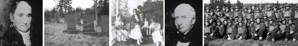
Thomas Culliton, a Roman Catholic farmer, lived on McNabs Island with one female (presumably his wife Sarah) in 1827. He died on December 12, 1837, "in the 73 year of his age ... deeply regretted by his acquaintances and friends." His wife died in 1833 and both are buried in the cemetery on McNabs Island. Thomas was, most likely, a brother of Joanna and the brother-in-law of Peter II.
A map of the island completed in July, 1865, shows a number of inhabitants scattered throughout McNabs Island (Figure 16). The Hugonin house is shown, although the owner's name is not given, a consequence of Hugonin's departure for England only two months previous. The Innes Farm is located a short distance north of the Hugonin house. A photograph of the farm (Figure 11) taken about 1875 shows three houses and a number of outbuildings. The large two story house on the left is the recently constructed residence of James Findlay. The centre house, partially hidden by the picket fence, and the house on the right, are both much older. One of the two may have been previously occupied by "Black Harry" who, as records indicate, "lived in the vicinity of the Findlay house."
Three buildings referred to as the "Timmons Farm," are shown near Timmonds Cove. These buildings may have been occupied at various times by the soldier Timmons, Peter Oates, or John Cooney, to name but a few.
John McCurdy, a tenant of Captain Hugonin, farmed on Hugonin Point.
Church's 1865 map of Halifax County also shows several inhabitants residing on McNabs Island. In addition to Captain Lyttleton, Roderick Hugonin and Mrs. McNab (widow of Peter III), an S. Tupper, farmer, is shown near Back Cove, an E. Timmins near Timmonds Cove, a Kuhn near Indian Point and a Trider near the soon-to-be- constructed Fort Ives.
In 1866, a new school house was built for the benefit of island children.
Despite a long history of activity and occupation at Indian Point, it appears that by the late 19th century the area became uninhabited. An 1886/88 map shows no cultural features in this area except an old orchard. This state apparently continued into the early 20th century. Ives Cove and the northwest section of Indian Point became popular again in the 1930's and 1940's when numerous cottages, many, if not all owned and rented by Matthew Lynch, small houses, a school, a church and a bandstand were established.